

Chapter 4: Mapping the Mind
By Emmanuel Mihiingo Kaija
Opening Quote
“If the map doesn’t show the well, the traveler will die of thirst.” — African Proverb
Part 1: Introduction — The Power of the Map in the Human Imagination
Maps are not innocent drawings; they are psychological tools that shape how people perceive the world, their neighbors, and themselves. When a child first looks at a globe, the colors and boundaries etched upon it teach more than distances—they encode hierarchies, power, and belonging. Scholars like J.B. Harley, in his classic work The New Nature of Maps (2001), argue that maps are never neutral, for they are “a language of power” written in lines and legends. Colonial maps of Africa, for example, exaggerated the size of European territories while rendering African kingdoms as empty spaces, suggesting a vacuum waiting to be filled. Even the famous Mercator projection, still widely used today, magnifies Europe and North America while shrinking Africa—psychologically reinforcing the myth of a “small Africa” and a “large Europe.” Such distortions sink deep into the subconscious, so that both colonizer and colonized internalize a false sense of Africa’s insignificance.
In African oral wisdom, however, the map has always been more than lines on paper—it was a memory woven into stories, songs, and proverbs. The proverb, “If the map doesn’t show the well, the traveler will die of thirst,” carries both literal and metaphorical weight. Literally, it warns that a map that ignores water is a death sentence for the wanderer. Figuratively, it teaches that a worldview that erases human needs—wells, homes, shrines, graves—invites destruction. Here lies the psychological battle of cartography: a colonial map that highlights diamonds but omits the village nearby is not merely incomplete, it is a weapon. It directs the gaze toward wealth and away from the people who live upon that land. Thus, to understand Africa’s colonial and postcolonial psyche, one must interrogate how maps have functioned as silent teachers of value, deciding what counts and what can be forgotten.
This power of the map is not abstract. In Uganda, for instance, the colonial maps of the Buganda kingdom prepared by British surveyors between 1900–1920 prioritized tax zones, cash crop plantations, and administrative roads over sacred groves, clan boundaries, and traditional shrines. Anthropologist Derek Peterson notes in Ethnic Patriotism and the East African Revival (2012) that such cartographic erasures had profound spiritual consequences: shrines vanished from maps, and within a generation, people began to forget the sacred landscapes where their ancestors had prayed. In contrast, precolonial Ethiopian church maps, often painted on parchment, placed Eden at the center of the world, rivers flowing outwards, and mountains marked not by minerals but by monasteries. One map teaches extraction, the other devotion. The psyche molded by the colonial atlas sees wealth in copper and cobalt; the psyche molded by indigenous mapping sees wealth in wells, kinship, and spiritual continuity.
Part 2: Psychological Effects of Resource-Centered Maps
When a map prioritizes resources over people, it plants a subtle seed in the mind: land is not primarily a home, but a warehouse of commodities waiting for extraction. This is a psychological reprogramming. Instead of seeing rivers as lifelines of community, maps drawn by colonial administrators painted them as transport corridors for ivory, rubber, or cotton. Instead of marking shrines, markets, or grazing fields, colonial maps etched red lines around mining concessions and plantations. The result was a gradual erasure of human belonging from the landscape, both in the imagination of colonizers and the colonized. Achille Mbembe, in On the Postcolony (2001), describes how this “cartographic violence” framed Africa as an object of exploitation, a blank stage upon which European greed could be inscribed. Maps therefore were not simply guides; they were scripts for domination, and Africans, stripped from the paper, were forced into the margins of their own story.
The psychological consequences of such maps persist today. A young student learning geography in Kinshasa or Kampala may still inherit an atlas that emphasizes oil fields, cash crop zones, or “economic potential” rather than sacred lakes, indigenous languages, or cultural landmarks. This reinforces a worldview where value is calculated in barrels and tons rather than in ancestral memory or community well-being. Studies in environmental psychology have shown that when people are repeatedly exposed to maps that highlight extractive zones, they internalize the logic of commodification and begin to see their environment less as a shared inheritance and more as an expendable resource. In Ghana, where colonial maps once delineated cocoa export routes, villagers interviewed in contemporary research (Boamah, 2014) confessed that they sometimes think of their forests “first as income and second as home.” This is the enduring legacy of cartography as ideology: maps that foreground resources subtly reshape the human mind to accept exploitation as natural.
Colonial atlases also trained the eye to ignore suffering. Consider the rubber maps of the Congo Free State under King Leopold II. These maps displayed stations, supply routes, and quotas of rubber, but erased the atrocities of forced labor, the cut hands, the millions who died. To the European investor in Brussels, the map promised wealth; to the Congolese child, the same cartography concealed death. The dissonance is psychological manipulation at scale: if the atrocity is not drawn, it is easier to deny. This dynamic repeats itself today in multinational oil company maps that highlight drilling blocks in Nigeria’s Niger Delta without a trace of the devastated fishing villages or oil-slicked mangroves. Cartography here functions as a corporate blindfold, seducing the mind to believe in profit while erasing pain.
African wisdom counters this erasure. The Swahili say, “Ramani haionyeshi roho ya mtu”—“A map does not show a person’s soul.” This proverb reveals a cultural recognition that maps can never fully represent life. When the cartographer prioritizes copper veins over clan boundaries, what is lost is not only geographical detail but human dignity. The traveler, seeing only lines of profit, forgets that a well quenches thirst, that a graveyard tells history, that a shrine holds memory. By privileging resources, the map seduces the mind into an extractive imagination, where the earth becomes a ledger and its people mere background noise. To decolonize the psyche, one must learn to see what the map refuses to show.
Part 3: Colonial Atlases — Instruments of Control
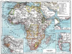
Colonial atlases were not books of geography alone; they were manuals of conquest. Bound in leather and printed with precision, these atlases disguised domination as science. When European powers convened at the Berlin Conference of 1884–85 to partition Africa, they did not bring armies into the conference hall—they brought maps. Straight lines sliced across the continent with the ease of a ruler, ignoring rivers, mountains, and people. What emerged were borders like scars, visible today in the geometric edges of Chad, Libya, or Namibia. These maps were instruments of control because they declared ownership before a single soldier had stepped onto the soil. To paraphrase the historian Benedict Anderson in Imagined Communities (1983), the colonial atlas allowed Europe to “imagine” Africa as a possession, a jigsaw puzzle whose pieces could be bought, sold, and traded.
The power of these atlases lay in their authority. A line drawn on paper in London or Brussels was soon enforced on the ground by administrators and troops. In Uganda, the 1900 Buganda Agreement was accompanied by a flurry of British survey maps, which delineated “Crown land” from “native reserves.” Villages that had existed for centuries found themselves erased, their inhabitants reduced to squatters on paper that was already deemed “official.” Terence Ranger, in his classic essay The Invention of Tradition in Colonial Africa (1983), notes that such cartographic practices created new identities by force: a Muganda whose ancestral land fell outside the mapped reserve was reclassified as a tenant, his identity reshaped by a line on a colonial atlas. Control was therefore not only physical but psychological—maps taught Africans to think of themselves as subjects within alien boundaries.
These atlases also carried propaganda. Schoolchildren in colonial Africa were often taught geography from European-published textbooks filled with maps that glorified empire. The red of the British Empire sprawled across Africa, while indigenous kingdoms and empires were left invisible. To a young child in 1920s Kenya, to open such an atlas was to see their homeland painted not as Kikuyu land, but as a province of Britain. The psychological impact was profound: one learns to see home not as sovereign space but as a colored block belonging to someone else. As Ngũgĩ wa Thiong’o observed in Decolonising the Mind (1986), colonial education made the African alien to his own soil, teaching him to “look at Africa with the eyes of a stranger.” Maps were central to this estrangement.
The violence of colonial atlases extended to the imagination of Europe itself. In Paris or Lisbon, the ordinary citizen could flip through an atlas and gaze at territories thousands of miles away, painted in their national colors. These images created what anthropologist Mary Louise Pratt calls in Imperial Eyes (1992) “the domestic subject of empire”—the sense that even those who never traveled beyond Europe were part-owners of African lands. Thus, the atlas created psychological colonies not only in Africa but also in Europe: Africans were reduced to subjects, Europeans elevated to rulers, all through the silent authority of lines and colors.
An African proverb whispers the counter-truth: “The stranger draws the map, but he does not walk the path.” The atlas could impose boundaries, but it could never erase the lived knowledge of the land—the hidden wells, the sacred groves, the winding footpaths. Yet the tragedy is that the colonial atlas was elevated above oral memory, given the stamp of “truth” in courts, schools, and administration. To resist such control, Africans had to preserve their mental maps in story, song, and ritual, a quiet rebellion against the tyranny of paper.
Part 4: Indigenous Mapping Traditions — Ethiopia & the Swahili Sea-Roads
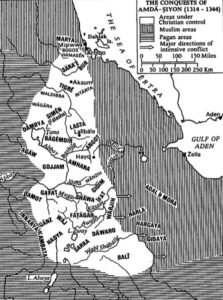
Indigenous African cartographies did not merely plot coordinates; they braided cosmology, ecology, and memory into spatial knowledge—a choreography of land and lineage. In the Ethiopian highlands, church worlds were drawn as theology in ink: concentric-circle maps that seat Aksum near the heart of a sacred geography, the earth encircled by biblical rivers—an iconography that teaches orientation as devotion. Scholarly surveys of African mapmaking document such Ethiopian “mappae mundi” embedded in manuscripts (including versions associated with the Kebra Nagast), where place is nested inside covenant, pilgrimage, and kingship; the map is liturgy that you can point at. In the seventeenth century, the Ethiopian scholar Abba Gorgoryos co-produced a map of Ethiopia with the orientalist Hiob Ludolf, rendering a landscape “flowed around by the Nile/Gihon” and inflected by indigenous classificatory habits—evidence that Ethiopian cartographic thought negotiated with, rather than yielded to, European forms. Against the colonial atlas’s extractive gaze, these church maps staged a counter-epistemology: the world is not a warehouse; it is a covenantal circle whose center is a story.
On the coast, Swahili mapping looked less like a static sheet and more like a seasonal sentence. The “chart” was a repertoire: monsoon names (Kaskazi, the northeast wind; Kusi, the southwest) timed departures and returns, and pilots translated wind, current, and star into itineraries. Indian Ocean navigational science—codified by the fifteenth-century navigator Ahmad ibn Mājid in his Kitāb al-Fawāʾid fī Uṣūl ʿIlm al-Baḥr wa’l-Qawāʿid—circulated among Swahili, Arab, and Gujarati mariners, listing routes, capes, shoals, and the geometry of rhumb lines: a text-atlas for a sea without buoys. Earlier still, the Periplus of the Erythraean Sea (1st c. CE) reads like a proto-gazetteer for East Africa—Rhapta and other emporia plotted as narrative waypoints—showing how coastal Africans were already woven into long-distance circuits where “map” meant itinerary plus monsoon clock. Historians of the Swahili world underline how these monsoon logics structured a “bipolar” coast with hubs like Kilwa and Sofala, the winds themselves anchoring a mental map that pulsed November to August, out and back.
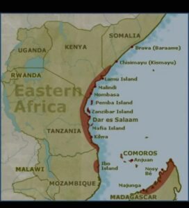
Because these mappings lived in bodies and boats, not just on vellum, they left traces in chronicles and practices: the Kilwa Chronicle sited power along the monsoon hinge; dhow culture remains an embodied cartography in which hull and sail “remember” the route. Anthropologists and maritime historians track how pilots synchronized departures with Kaskazi and Kusi, staying months in distant ports as seasonal knowledge dictated—an archipelago of waiting that doubled as a map of hospitality. Here, “resource map” reduces to absurdity; the sea road’s value is the choreography itself—pearls of timing, reefs of caution, harbors of reciprocity. The Swahili proverb could be paraphrased thus: to know the route, learn the wind’s biography.
Indigenous mapping in Africa also exceeded lines and coasts by storing space in things: the Luba lukasa memory boards—pebbled, beaded, and carved—operate as conceptual atlases of polity, migration, and sacred topography, read by experts with the fingertip as compass. Museums and art historians describe them as territorial diagrams and historical chronicles fused into handheld cartography—proof that a “map” can be a ceremony. When set beside colonial atlases, these traditions reveal the philosophical divergence: one maps to command extraction; the other maps to sustain relation. Here the African proverb bites: If the map doesn’t show the well, the traveler will die of thirst. The Ethiopian circle and the Swahili monsoon itinerary place the wells back on the page—springs of memory, liturgy, wind, and route—so that travel does not forget its ethics.
Part 5: The Clash of Worldviews — If the Map Doesn’t Show the Well…
The African proverb, “If the map doesn’t show the well, the traveler will die of thirst,” is more than a poetic warning. It is an epistemological critique. Colonial cartography plotted roads, mines, and plantations but left out shrines, wells, and footpaths—the very infrastructures of life. In this erasure lay a clash of worldviews. Indigenous African mapping traditions, whether the Ethiopian church cosmologies or Swahili wind calendars, were designed to sustain life and memory. They told you where to find water, where to pray, and how to orient yourself in relation to the sacred and to neighbors. Colonial atlases, by contrast, were utilitarian instruments of extraction, their “wells” were resource nodes—gold veins, cotton belts, copper mines. Where the Ethiopian monk painted paradise at the center of the earth, the colonial surveyor penciled out concessions for mining syndicates. Where the Swahili sailor charted monsoon rhythms to ensure safe passage, the colonial governor drew tax zones and railway corridors to accelerate extraction. The contradiction is stark: one maps to nourish; the other maps to consume.
This clash has enduring consequences. Political geographers such as Matthew Edney emphasize that colonial maps were “propositions of power” that disciplined space by teaching both rulers and ruled what mattered and what could be ignored. When wells and sacred groves were excluded from the official maps of Kenya or Uganda in the early twentieth century, they began to lose their legal and cultural recognition. Anthropologist Derek Peterson documents how shrines once vital to Gikuyu life were zoned out of existence when land was surveyed for coffee plantations, a process accelerated by colonial cadastral mapping. By contrast, oral cartographies preserved in Kikuyu songs or Ethiopian liturgical maps preserved a memory of these wells and groves as sacred, ensuring their survival in community consciousness. Here we see a double mapping: one on paper, the other in memory. One empowered empire, the other sustained resilience.
The colonial erasure of life-giving sites also enabled atrocities of resource plunder. In the Congo Free State, the rubber extraction maps never recorded villages—only stations and quotas. To European investors, these maps suggested a land rich in rubber but empty of people; to the Congolese, they concealed the forced labor, mutilations, and millions of deaths. In Angola and Mozambique, Portuguese colonial cartography was similarly obsessed with railways and export nodes, while omitting indigenous farming systems. Such cartographic silences became self-fulfilling: if the map ignored the village, so could the law.
The indigenous proverb thus speaks prophetically: a map without wells is not merely incomplete—it is a death sentence. Wells are metaphors for justice, memory, and dignity. If a nation’s map does not “show the well”—its cultures, languages, sacred sites—its citizens will thirst for belonging, for recognition, for history. Ngũgĩ wa Thiong’o makes this point in Decolonising the Mind (1986): when colonial education replaced indigenous narratives with alien geographies, it created a spiritual drought, teaching Africans to look at their homeland “with the eyes of a stranger.” The proverb confronts this drought: life cannot flow from maps that erase life.
Evidence of this psychological clash persists in the postcolonial state. Many African governments still rely on colonial-era cadastral maps, prioritizing concession zones for oil or mining above the survival needs of communities. In the Niger Delta, oil block maps are drawn with precision, but the polluted rivers and devastated fishing villages remain unmapped, leaving the people legally invisible. In contrast, grassroots movements have begun reclaiming indigenous mapping—community mapping projects in Kenya, Tanzania, and the Congo Basin now record wells, sacred forests, and clan boundaries omitted from state maps. These efforts echo the proverb: if we do not draw the wells, we will continue to thirst.
Thus, the proverb functions as both diagnosis and cure. It diagnoses the violence of extractive cartographies that erase life, and it prescribes the necessity of re-centering the map on what sustains. The Ethiopian circle maps, Swahili wind charts, and Luba lukasa memory boards already carried this ethic: they mapped so that people would not die of thirst—not only for water but for meaning. By retrieving these traditions, Africa can begin to heal from the psychological wounds of maps that served empire rather than people.
Part 6: Conclusion — Decolonizing the Mind Through Maps

Maps are never mute. They are sermons preached in ink, and every line is a theology of space. Colonial atlases, as we have seen, were not innocent guides but weapons of control. They erased shrines, wells, kinship boundaries, and ecological wisdom, while amplifying railways, mines, and export corridors. They taught colonizers and colonized alike to view Africa not as a home but as a warehouse of resources. Scholars like J.B. Harley remind us that cartography is always “a discourse of power,” for what is not drawn becomes invisible in law, memory, and imagination. The psychological violence of such omissions has left deep scars: Africans trained to see their land through foreign projections, Europeans persuaded to believe they owned territories they had never seen. This is the cartographic wound that still bleeds into the postcolonial present.
To decolonize the mind is to redraw the map. Not merely by changing borders, but by re-centering what matters. Indigenous cartographies already offer a template. Ethiopian church maps placed rivers, mountains, and monasteries within a sacred cosmology, reminding pilgrims that geography is also theology. Swahili navigators mapped with winds and stars, transforming the Indian Ocean into a lived calendar of exchange, memory, and reciprocity. Luba lukasa boards embodied entire territorial histories in beads and carvings, making maps into memory-tools that preserved lineage and justice. These traditions reveal a profoundly different ethic: to map is not to dominate but to sustain. If the well is absent, the map is a curse; if the well is present, the map becomes life.
The consequences of ignoring this ethic remain tragically clear in modern Africa. Oil block maps in the Niger Delta are meticulously drawn, while the poisoned rivers and destroyed villages remain unmapped. Mining concession maps in the Congo highlight cobalt deposits feeding the global tech industry, yet the communities displaced by toxic tailings are invisible on official charts. These silences perpetuate colonial logic under new corporate names. As anthropologist Nancy Peluso argues in Political Forests (1995), maps continue to be deployed to turn landscapes into “resource frontiers,” legitimizing dispossession while cloaking violence behind technical lines. The cartographic wound has not healed; it has been rebranded.
Yet there is resistance. Across the continent, grassroots projects are reclaiming cartography. In Kenya, Maasai communities have created participatory maps marking grazing lands, water sources, and sacred groves once ignored by state maps. In Tanzania, Hadza hunter-gatherers are using GPS-based mapping to record berry patches, hunting routes, and ritual sites, protecting them from land grabs. These initiatives echo the ancient proverb: they ensure the well is shown, so the traveler—the future generations—will not die of thirst. By blending modern tools with indigenous priorities, such projects point toward a cartographic decolonization that is both practical and psychological.
The theological dimension is equally vital. The Bible itself is filled with sacred geography: Eden at the center, rivers flowing outwards (Genesis 2:10–14); the Promised Land described with mountains, valleys, and springs (Deuteronomy 8:7); Zion as both a place and a symbol of divine dwelling. Like Ethiopian church maps, biblical cartographies remind us that place is never neutral. To map without wells is to sin against creation; to map with wells is to honor God’s gift of land and life. African theologians such as John Mbiti have long insisted that “to live is to be located,” that spirituality is inseparable from land, ancestors, and memory. To reclaim the map is therefore not only a political project but a spiritual restoration.
Thus, the conclusion crystallizes: decolonizing the mind through maps means teaching new generations to interrogate every line and legend. It means asking, “Who does this map serve? What does it omit? Where is the well?” It means dismantling the psychological inheritance of colonial atlases and restoring indigenous cartographies of life. It is to return to the wisdom of the proverb: “If the map doesn’t show the well, the traveler will die of thirst.” A decolonized map quenches thirst by honoring memory, sustaining community, and reminding us that geography is not property but kinship. In this cartographic reawakening lies the healing of both land and mind.
References
Books and Monographs
Edney, M. H. (1997). Mapping an empire: The geographical construction of British India, 1765–1843. University of Chicago Press.
Peluso, N. L. (1995). Rich forests, poor people: Resource control and resistance in Java. University of California Press.
Peterson, D. R. (2004). Creative writing: Translation, bookkeeping, and the work of imagination in colonial Kenya. Heinemann.
Journal Articles
Edney, M. H. (2004). Power of colonial maps. MO3351 Doing and Practicing Transnational and Global History. Retrieved from https://transnationalhistory.net/doing/2016/03/04/power-of-colonial-maps/
Peluso, N. L. (1992). Whose woods are these? Counter-mapping forest territories in Kalimantan, Indonesia. Antipode, 24(1), 1–20. https://doi.org/10.1111/j.1467-8330.1992.tb00216.x
Websites and Online Resources
Edney, M. H. (n.d.). Cartography: The ideal and its history. University of Chicago Press. Retrieved from https://press.uchicago.edu/ucp/books/book/chicago/C/bo34094164.html
Peluso, N. L. (n.d.). Nancy Lee Peluso – Google Scholar. Retrieved from https://scholar.google.com/citations?hl=en&user=Yop9lqUAAAAJ
Peterson, D. R. (n.d.). Derek Peterson – MacArthur Foundation. Retrieved from https://www.macfound.org/fellows/class-of-2017/derek-peterson
Reports and Working Papers
Peluso, N. L. (2011). The political forest in the era of green neoliberalism. The Journal of Peasant Studies, 38(4), 1–22. https://doi.org/10.1080/03066150.2011.621264
Copyright
© 2025 Emmanuel Mihiingo Kaija. All rights reserved.
Short excerpts may be shared on social media with full credit to the author. Any other reproduction or commercial use is prohibited.
Source: African Publicity


